Keep in mind the penciled area is inaccurate......this photo is from Websleuths.
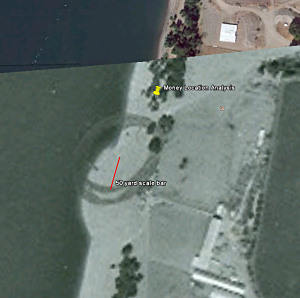
Fig. 3 1974 dredging image from FBI archive overlaid on Googe Earth. The penciled circle is the inaccurate location of the money find from 1980. The pronounced hump in the beach is the result of the dredging pipe dumping sand on the beach. The red line represents the distance sand was moved north on the beach from the dredging pipe. The yellow pin marks the recoverd position of the money find.
The circles were never intended to be accurate, according to Larry. In fact if you look at the photos 1970-79 the
position of the circles varies - some enclose the Kaye GPS position and some don't. The fact is, I'm not even sure how accurate Tom's recovered position is. When I asked Brian if he knew the exact place where the money was found he said "No'. He said 'Tom made a good estimate'. That is basically why until something better surfaces, I take Tom's position as the best estimate to date. I don't know that anyone ever surveyed the exact location just after the Ingram's has found the money ?
When Meyer Louie and I paid a visited to Tina Bar in July, 2013, we used a hand held GPS to locate Tom Kaye's GPS coordinates for the money find location. The east-west (longitude) coordinate that Tom gives is now actually several feet off shore and underwater. But the north-south (latitude) coordinate indicates that the money was found between the containment pit and the water line as it existed at they existed in 1980. And that point is basically in the middle of the pencil circles in the 1974 picture.
Additionally, I think the picture of about 10 FBI agents digging at the find location can be used to support the above location by comparing the objects shown on the west side of the Columbia River to their locations on a topographical chart. Using all means to define the location, I think the paper pins are in the wrong positions. They are to far north and the money was found south of them. To repeat, multiple sources seem to agree that the money was found between the west wall of the containment pit and the river water.
The yellow pin on the 1974 map indicates the approximate location of an outdoor john (at least in 2013). And the money find location is slightly north of the end of the red line.
Well, if you are correct a d Tom's chart is wrong, that dismisses Tom's objections based 'distance away from the north dredge spoil site'. Let me go back and read Tom's website for the umpteenth time. If the money find was right over the 1974 spoil pile that opens other possibilities based on other data Tom collected ... I just wish we could get this location settled once and for all. I have at least six different locations from different 'experts' who have supposedly been to Tina Bar, several more who have never been there. One contended (with a map!) that the money was found clear down on the south end of the Fazio property .... and it goes on and on.
BTW: most people seem to agree that Palmer's trench was dug just to the side (south) of where the Ingram's said they had found the money; and several agents who were there confirmed that to me.
In February 2013, Tom Kaye had the following statement on his web page in his discussion of the Tena Bar Money find:
"The GPS position of the recovered money find was determined to be at: lat. 45.717888, long. -122.759500."
I don't remember seeing a map with this position plotted in Tom's discussion. But Meyer Louie and I went to that position (at least as close as we could get) using a hand held GPS to determine the coordinates.
And as I have stated previously in this discussion, that position is between the containment pit and the water's edge (as it existed in 1980) and roughly in the middle of the pencil circles on the 1974 map. These circles are labeled in your attached photograph as "Wrong/JT".
Additionally, in our lengthy discussions with "Jon", the Tina Bar regular, he made no effort at all to say that we were in the wrong place for the money find.

 Poll
Poll